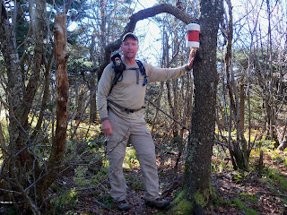
This climb starts out on the Spruceton Trail that eventually leads over to Hunter Mountain. I have used trail heads along Spruceton Rd. multiple times in the last three weeks for several other mountains. (West Kill and South West Hunter) This trail starts out following the Hunter Brook and once you cross a new wooden bridge over the stream and come to a notable switch-back, you leave the trail and begin the bushwhack north. It was very steep and the low under growth was thick. I had taken pity on Sarge and gave him another chance to come along. I'm not sure if it was the fact that there was no trail to follow or that I made him wear his pack, (nothing in it, but it slows him down) but he stayed much closer today.

It ended up being one of those days that I was glad that I had invested a lot of money in a good GPS because once you have climbed up the majority of the elevation, the true summit is sometimes hard to find when the top of the mountain is basically flat. It (the GPS) kept pointing me in the right direction, because finding a small canister on the top of a mountain is literally like
"finding the needle in the middle of a haystack." People start
bushwhacks from a variety of different locations. This leaves no discernible trail until you get close to the summit where everyone converges towards the canister. I finally picked up a
herd path that led me right to it. There is always more of a feeling of satisfaction on these trail-less hikes, because anybody can follow a trail,

it takes work to find a canister. After the required picture (I take them to make sure that Sandy knows that I am actually climbing mountains, not sitting at the cabin drinking beer... that comes later) and signing into the notebook in the canister. I started the "much tougher than I thought" climb down. I had told several people prior to starting this quest that I wasn't worried about getting lost in the Catskills because when in doubt, you just find a dry stream bed or working spring, follow it until it meets with a stream, follow that until it meets with a creek, follow that until it meets with a river and follow that until it leads to a road. Using that theory, I followed the head waters of the Hunter Brook down through the Ox Hollow along a much tougher descent than I had originally planned. Sarge actually looked at me a couple of times with that "are you kidding me?" face. We made it back to the Spruceton Trail, safe and sound, and ran into the first other hikers that I've seen in several days. (Wow... people, what a concept). I am actually contemplating a new plan that has me completing this whole event. (35 in 30 days) It's not a guarantee, but I do think that I have a better chance than I thought last week after being forced off the trail due to the torrential downpours and flooding. "35 Peaks in 30 Days" still might happen...

One of the good points about this hike is, I get to pass by the strategically placed Mountain Brook Inn, my new favorite bar. A good place for a celebratory cold beer and conversation with the owner, Mark which gives me a touch with reality before I head back to
Phoencia.


Looks like a great day!! I do worry a little more when it is a 'bushwack" you strike out on. Not about your skills, but about running out of batteries for the GPS, you and Sarge feeling you can take on a bear, etc. I just want you able to return home!!! The Mountain Brook Inn looks comfortable. I imagine it is nice to know someone when you have been almost "peopless" for almost 30 days!!!
ReplyDelete